Apply to serve on a San Rafael Board, Commission or Committee!

 
bikeped

Citywide Bicycle and Pedestrian Plan (CBPP) Update


Subscribe to receive email updates about this project!

* indicates required

Project Contact

Kelly Abey
City Project Manager

Monique Fuhrman
City's Consultant Project Manager

What Is the San Rafael Citywide Bicycle and Pedestrian Plan? 

The City of San Rafael is currently updating its Citywide Bicycle and Pedestrian Plan (CBPP), which was last updated in 2018. The updated plan will serve as a roadmap for improving walking, biking, and rolling in San Rafael over the next 5-10 years. It is an opportunity to reaffirm community priorities, analyze new data, and incorporate the latest trends and best practices. Our goal is to make San Rafael safer, more accessible, and more connected for everyone, whether you're walking to school, biking to work, or using a mobility aid. 

The CBPP update process is expected to last 12-14 months, with various opportunities for community members to get involved and provide input. See below for more information and to sign up for the project electronic mailing list to receive updates and notifications regarding the plan update. 

Plan Goals 

The CBPP update will be guided by several goals that will be based on shared community values, the City’s priorities, and best practices in other nearby jurisdictions. We need your input to set goals for this plan! Tell us what matters most to you—whether it's safety, accessibility, or better connections to transit. Take our online survey to let us know your thoughts 

Project Timeline 

  Spring 2025    Existing Conditions, Challenges and Opportunities 
  Fall 2025    Draft Active Transportation Network, Priority Projects and Programs 
  Spring 2026    Adoption of Updated Citywide Bicycle and Pedestrian Plan 

We Want to Hear from You! 

Where do you like walking, biking, or rolling? Where are you hesitant to walk, bike, or roll? How would you improve the experience?  

A key component of this plan is input from the community and bike/pedestrian network users.  There are a couple ways you can engage with our team to let us know your thoughts on walking and biking in San Rafael: 

Give Input in Person 

May 3rd 12-4PM: Nuestro Canal, Nuestro Futuro Community Fair
711 Grand Avenue, San Rafael, CA 94901

May 14th, 5-7PM: In-Person Open House
618 B St, San Rafael, CA 94901

Check back here for information on upcoming in-person outreach events. 

Give Input Online 

Click here to take the survey!

Take this survey to let us know how you walk, bike, and roll in San Rafael. Survey responses are anonymous and will be included in the final plan document appendix, but cannot be viewed by other website visitors. 

Need assistance completing the survey? Call us! (415) 485-3355

Add a comment in the interactive web map below to tell us about:

  • Walking and biking support: Where you like walking  and biking/rolling
  • Walking and biking challenges: Where are you hesitant to walk  and bike/roll ? How would you improve your experience? 


Instructions:  

  • Click the “Add location” button and leave a marker on the location you would like to leave a comment.  
  • Click the layer icon to view map layers that show the types of existing bicycle infrastructure.

Need assistance using the interactive map tool? Call us! (415) 485-3355


Web map comments are public, allowing you to see comments that other community members have added and vice versa, and will be included in the final plan document appendix. Comments with any amount of profanity may be auto-moderated for staff review before appearing on the map. Please be respectful of your fellow citizens when using the tool.  


What is Walking and Rolling in San Rafael like today?  

The City's consultant team is developing a technical analysis of existing conditions. We would also like to know if these findings align with your experience. Recommendations will be developed based on community input and detailed analysis. The following is an overview of San Rafael’s existing bike and pedestrian network, as well as other pertinent information relevant to the network.  This information forms the basis of the plan. 

Existing Pedestrian Project Types 

San Rafael already has several types of pedestrian and bicycle infrastructure, each designed to improve safety and access. Here are some examples:  

High Visibility Crosswalks with continental striping that are more visible to drivers.

Curb Extensions extend the sidewalk or curb line out into the roadway or parking lane, reducing the effective street width and crossing distance.

Rectangular Rapid Flashing Beacon (RRFB) installations at uncontrolled crossings to increase driver awareness of pedestrians at crosswalks. Pedestrians can activate the flashing signal with a button.

Pedestrian Hybrid Beacon (aka HAWK) is an intermediate option between a flashing beacon and full pedestrian signal. It helps pedestrians safely cross higher-speed roadways by assigning right of way and providing positive stop control.

Leading Pedestrian Intervals at signals provide pedestrians with an advanced walk phase before turning vehicles. This improves the visibility of pedestrians and reduces vehicle conflicts.

A recent example of pedestrian improvements is the installation of RRFBs at six of the most heavily used intersections in the Canal neighborhood, including across Canal Street at Bahia Way, which assists students and other pedestrians to safety travel between Bahia Vista Elementary School and the Pickleweed Community Center. Intersections along Third Street in downtown were also upgraded from transverse crosswalks to high visibility crosswalks in 2024. 

Existing Bicycle Project Types

The following represent the five types of existing bikeways in San Rafael: 

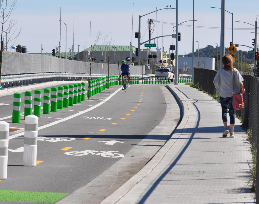
Class I Multi-Use Paths can be used by both bicyclists and pedestrians and are completely separate from the roadway.

Class II Bike Lanes are lanes that are painted on the street and can sometimes include a painted buffer from vehicle lanes.

Class III Bike Routes are shared lane bikeways that are not accompanied by speed calming measures and are indicated by signage and/or bicycle stencils called ”sharrows”; they may have higher vehicle volumes and speeds than bike boulevards.

Class III+ Bike Boulevards are shared lane bikeways accompanied by traffic calming measures such as speed humps.

Class IV Separated Bikeways are on-street bikeways with vertical, physical separation from the adjacent lane; these are most common on higher-speed roadways.

The City has continued to improve its bike network using the 2018 CBPP as a guide. Examples of recent improvements include new Class IV separated bikeways on Francisco Boulevard West between Second Street and Rice Drive and on Grand Avenue from Second Street to Fourth Street. These new bikeways increase bicyclists’ comfort by providing a dedicated space that is physically separated from traffic.  


Maps of Existing Conditions

The CBPP update is aligned with other planning efforts the City of San Rafael has undertaken in recent years. In 2024, the City adopted its Local Road Safety Plan, which is a framework to identify, analyze, and prioritize safety needs and improvements for all road users including pedestrians, bicyclists, and all individuals that travel by active modes.  

This map shows pedestrian-involved collisions based on the most recent six years of data. There were 229 collisions involving a pedestrian, including 6 fatal collisions, and 34 severe injury collisions. This data helps us identify high-risk areas and prioritize improvements to make walking, biking, and rolling safer in San Rafael. 

This map shows bike-involved collisions based on the most recent six years of data. There were 199 collisions involving a bicyclist, including 2 fatal collisions, and 20 severe injury collisions. This data helps us identify high-risk areas and prioritize improvements to make walking, biking, and rolling safer in San Rafael. 

This map shows schools, parks, and a high-level overview of the residential, commercial, and institutional land uses in San Rafael. 


Plan Resources 

Here you can find the 2018 CBPP, as well as presentations and documentation from this update process. More will be posted as the Plan update gets underway. 

Close window