Updates to City Hall Hours on Fridays in July and August 


Priority Development Areas – 2020

Priority Development Areas Banner

Para traducir esta página, desplácese hasta el final, haga clic en "Translate", y seleccione su idioma.Translate Button Image

We want your feedback!

As part of the on-going work for San Rafael’s General Plan 2040, City staff has received requests for deeper planning efforts in the Canal neighborhood and around the Northgate Mall area. Planning efforts such as these require grant funding. MTC/ABAG has started developing Plan Bay Area 2050 and has asked jurisdictions for letters of interest for new Priority Development AreasA designation would bring funding opportunities for community-driven planning efforts. 

San Rafael currently has a Priority Development Area (PDA) in Downtown San Rafael. This designation helped bring $600,000 to San Rafael to fund a community-drive planning process (in progress). 

In the past, PDAs were half mile radius areas around a transit center, but now the ability exists to be much more precise and intentional with boundaries. The designation does not override local control for zoning and development approvals. The designation can be rescinded by San Rafael at any time. 

On Monday, May 18, 2020 the City Council heard an informational report about an upcoming opportunity to designate priority development areas (Watch the Meeting | Read the Staff Report). Now, the City Council wants to hear from you.  

  • Should the City continue to pursue a PDA-designation and funding for a PDA planning process for Northgate and Southeast San Rafael/Canal? 
  • What areas of North San Rafael  and Southeast San Rafael/Canal should and should not be included in a PDA-designation? 
  • What topics would you want included in a North San Rafael and Southeast San Rafael/Canal planning process? 

Need some of the above terms and acronyms defined? Scroll to the bottom of this page for definitions. 


How to Participate 

  1. Submit your ideas, questions, and comments below on the Neighborland website (Northgate PDA  |   Southeast San Rafael/Canal PDA). 
  2. Missed a virtual community meeting? Watch a recording of the meeting at the below links:
  3. Ask a question. The City will be continuously updating the Frequently Asked Question section of the webpage below. If you don’t see your questions answered, let us know! 
  4. Attend the June 15, 2020 City Council meeting. You can call in or participate via live chat on YouTube. 
  5. Send a letter. You can email your letter toethan.guy@cityofsanrafael.org  

Frequently Asked Questions

First, a Priority Development Area or “PDA” is a place that has convenient public transit service that is prioritized by local governments (cities/counties) for housing, jobs and services. PDAs range from Downtowns to Main Streets to aging shopping malls.

Second, a PDA is a funding and planning tool.  If a local jurisdiction voluntarily nominates an area for PDA designation, the designation provides the local jurisdiction with access to funds and grants to: a) develop and adopt area Plans to plan for, design and regulate future growth of the area; and b) constructed needed and/or planned infrastructure improvements.

PDAs are voluntarily nominated by the local jurisdiction. Further, the local jurisdiction has the full discretion to set the boundaries of the PDA within the eligible PDA areas that have been identified by Plan Bay Area.

Plan Bay Area 2050 is a long-range plan charting the course for the future of the nine-county San Francisco Bay Area. Plan Bay Area 2050 will focus on four key issues—the economy, the environment, housing and transportation—and will identify a path to make the Bay Area more equitable for all residents and more resilient in the face of unexpected challenges.

Click here for more information.

The Call for Letters of Interest to nominate a PDA was released on March 11, 2020, which was the same week the Shelter-in-Place Order was enacted.   The process to nominate a PDA has a specific time limit and deadline for filing.  A Letter of Interest to nominate an area for PDA designation must be submitted by the local jurisdiction to the Metropolitan Transportation Commission (MTC) by May 31, 2020.  A final, formal request to nominate a PDA must be made in the form of adoption of a resolution the local jurisdiction (City Council) and submitted to MTC by June 30, 2020.  MTC has not extended these deadlines.  

All PDA designations must be in an “urbanized area” and adopt a Specific or Precise Plan by 2025.

There are two main categories of PDA designations: Transit-Rich and Connected Community. MTC/ABAG describes these designation as the following:

  • Transit-Rich: The majority of land is within one-half mile of an existing or planned rail station, ferry terminal, or intersection of 2 or more bus routes with peak headways of 15 minutes or less.
  • Connected Community: The majority of land is within ½ mile of an existing or planned bus line with headways of no more than 30 minutes in peak periods.

For Connected Community PDAs, MTC/ABAG further separates these areas by whether they are a “High-Resource Area.” High Resource Areas are defined by the California Department of Housing and Community Development (HCD). HCD uses these definitions in their Opportunity Maps. The detailed methodology used to determine these areas, and a current map, are available here.

A full description of these designations can be found here.

There is no difference in the community-driven planning process between PDA-designations. All PDA-designations require a Specific or Precise Plan to be adopted by 2025.

Connected Community PDAs outside of a High Resource Area are required to also adopt policies to reduce Vehicle Miles Traveled (VMT). The City of San Rafael has already adopted these policies as part of our Bicycle and Pedestrian Advocacy. Links to these policies are below:

The Letter of Interest submitted by the City of San Rafael on May 29th with the below PDA-designations:

  • Northgate PDA: Connected Community within a High Resource Area
  • Southeast San Rafael/Canal PDA: Connected Community outside a High Resource Area

The Letters of Interest submitted on May 29th, 2020 can be viewed here:

The final PDA-designation will be determined by MTC/ABAG and will be determined by the PDA-designation for the majority of the PDA-area. For example, if a PDA area is 100 total acres and 51 of the acres is designated a Connected-Community, the entire PDA would be designated a Connected Community.

“Planned” and “Planned Year” refer to the information included in the City’s General Plan. The most recent General Plan was completed in 2015 and be found here: General Plan 2020

The number of “Planned” dwelling units listed in the LOIs comes from Table B3.11 in Appendix B of the Housing Element of the General Plan.

The number of “Planned” jobs listed the LOIs was left blank as the City’s General Plan does not include specific numbers of jobs.

The Letters of Interest submitted on May 29th, 2020 can be viewed here:

No. A PDA is a planning tool and does not zone, authorize or approve new development or other physical changes. Rather, a PDA provides access to funding to construct needed and/or planned infrastructure improvements aimed at addressing traffic  issues. Additionally, PDAs also provide access to funding to help facilitate a community-driven planning process that would better plan for the community’s traffic and parking needs. 

The primary benefit of creating a PDA is access to funding for a community-driven planning process.  The PDA provides access to funding sources such as grants, which can be used for land use and circulation planning, as well as needed and planned infrastructure improvements.

The most common funding source for a PDA is the One Bay Area Grant (OBAG) Program, which is administered by MTC. Established in 2012, OBAG taps federal funds to maintain MTC’s commitments to regional transportation priorities while also advancing the Bay Area’s land-use and housing goals. Cities and counties in the Bay Area can use these OBAG funds to invest in, among others:

  • Facilitating a community-driven planning process, like a Special Plan, for the PDA
  • Local street and road maintenance
  • Streetscape enhancements
  • Bicycle and pedestrian improvements
  • Transportation planning
  • Safe Routes to School projects

Most recently, the City secured $600,000 in OBAG funding to facilitate the development of San Rafael’s Downtown Precise Plan. Funding through the OBAG Program are launched in cycles  with funds released annually (“rounds”). The current cycle is OBAG 2, covering 2017-18 through 2021-22.


Most grant funding is for a specific deliverable not a PDA designation. These funding requirements would included in an agreement before any funds are awarded. For example. this deliverable could be a Specific Plan or a bike lane.
 
For OBAG grants, funding is designated for areas with a PDA. These are the main grant funds used for a community-driven planning process for a PDA. While each new annual round of grants will have its own requirements, past cycles fund a specific deliverable in a PDA. Once the funding is awarded the same PDA boundaries or designation has not been required. In most cases, changes to a PDA boundary show a successful community-driven planning process.

The Downtown PDA was established in 2009. Since it was established, there have been many accomplishments.  The City benefited from the specific PDAs funding from the One Bay Area Grant (OBAG) program.  OBAG grants greatly subsidized the preparation of two plans.  The City received $250,000 to develop the 2012 Downtown Station Area Plan and $600,000 for the pending Downtown Precise Plan. Also, because of the PDA status, the City was awarded OBAG funding for several infrastructure projects. These funds included  $2.1 million  for sidewalk improvements along Francisco Boulevard East and $1.9 million for Downtown transportation enhancement improvements to prepared for the SMART rail service.

To date, there have been no challenges or obstacles with the Downtown PDA.  The Downtown Precise Plan has been developed through a community driven planning process. This planning process was  funded the OBAG grants described above.  All of the Precise Plan contents and recommendations have been administered, shepherded and crafted solely by the City of San Rafael and our community.  During this process, there has been no intervention by or pressure from the regional agencies (MTC/ABAG) to influence the Plan findings or recommendations.

No. The PDA is first a funding tool and is part of Plan Bay Area, a regional plan which is strategic document only.  By State law (California Government Code Section 65080(b)(2)(K), Plan Bay Area cannot supersede local land use authority. Any changes to local planning and land use policies are solely the authority and control of San Rafael.

No. Local jurisdictions are not required to comply with Plan Bay Area. Further, the designation of a PDA does not obligate or mandate the local jurisdiction to comply with or meet any of the jobs and housing growth projections that will be developed as part of Plan Bay Area.

When a planning process begins, the City Council would decide whether to allow submittal of development project applications.

During the current General Plan 2040 and Downtown Precise Plan process, the City is accepting  applications. Applicants must sign a form acknowledging that the outcome of the Plan process could impact their project. These impacts could result in their application being denied.

While the Council could freeze development applications and processing, state laws create limitations. By State law, moratoriums are subject to strict time limits. A freeze must include findings of urgency and necessity to protect the health, safety and welfare of the community.

No, the designation of a PDA for an area does not mean that high rise buildings will be developed in the community.  A PDA designation is a funding and planning tool; it does not zone for or authorize land development. A PDA would help fund a community-driven planning process which would look at the density, height and types of future buildings that would be allowed in this area. 

By nominating a PDA, San Rafael is prioritizing a community-driven planning process looking at housing, jobs and services, and intensified land uses within this area.  Jurisdictions are required to conduct this process for this PDA by 2025 in order to maintain the PDA-designation. To help facilitate this process, designated funding is provided to jurisdictions with PDAs.

While there are similarities and overlap, each Plan type is distinctive and have different elements and purposes.   The purpose of all these plans to is conduct future planning.  The different plans look at a finer level of detail for future planning a specific geographic area.  The following is a description of each Plan type and how they differ. Plan types are listed from most detailed to least detailed:

Specific Plan. A Specific Plan is the most detailed of these plans and is defined and regulated by the State of California (State Government Code Sections 65450-65457).  What is unique about a Specific Plan is that it combines a policy document (ex. goals, policies and programs) with a regulatory document (zoning ordinance). Specific Plans serve as a standalone planning document, replacing the General Plan and citywide zoning ordinance for the Specific Plan area.  By law, a Specific Plan is required to include:

  1. land use regulations and development standards;
  2. a program of implementing measures;
  3. planned and needed public works projects to serve the Specific Plan area (essentially a capital improvement program); and
  4. financing measures necessary to implement the Plan and its recommendations.

A Specific Plan is subject to environmental review under the California Environmental Quality Act (CEQA).  CEQA often requires the preparation of an Environmental Impact Report (EIR). This EIR is required to have a greater level of detail and study than an EIR prepared for a General Plan.

Due to the detail of the EIR for the Specific Plan, State laws provide environmental review streamlining and exemptions. This streamlining and exemptions are only available for development projects (particularly housing projects) if they are consistent with the Specific Plan.

Precise Plan.  A Precise Plan is like a Specific Plan but more loosely defined.  Unlike a Specific Plan, the format and content of a Precise Plan can vary.  A Precise Plan usually will contain the same elements and content as a Specific Plan but will lack a financing component and capital improvement program. These elements describe how and when Plan implementation will be funded.  Further, unlike a Specific Plan, a Precise Plan remains under the umbrella of a citywide General Plan.

For example, the City is currently developing a Downtown San Rafael Precise Plan. This Precise plan will include all of the elements and content of a Specific Plan (including a zoning ordinance), but does not include a financial component.

A Precise Plan is subject to environmental review (CEQA) preparation of an Environmental Impact (EIR) that has a greater level of detail and study than an EIR prepared for a General Plan.  Therefore, it can offer environmental review streamlining for development projects that are determined to be consistent with the Precise Plan.

Community Plan.  A Community Plan is a part, or “Element,” of a local General Plan focusing on a particular area of the community within the local jurisdiction.  A Community Plan is a policy document that supplements the local General Plan.  A Community Plan presents goals, policies and programs that are specific and unique to the community or area that it covers. Unlike a Specific Plan or a Precise Plan, a Community Plan is not a regulatory document. Community Plans do not include zoning regulations or development standards.

A Community Plan is subject to environmental review (CEQA). This review may be covered by an Environmental Impact Report (EIR) prepared for the General Plan or by its own EIR.  Typically, the EIR that covers a Community Plan assesses environmental impacts at a general level which is not site specific.

Development projects in an area covered by a Community Plan must be reviewed to determine if the project is expemt from environmental review. This review is based on the specific site conditions and potential impacts. Exemptions are allowed if the project meets specific criteria.  The criteria must be documented through the preparation of an “Initial Study” checklist.

Neighborhood Plan. A Neighborhood Plan is like a Community Plan but is more loosely defined.  The detail, content and scope of a Neighborhood Plan can vary significantly. Neighborhood plans typically include a vision, data and demographics, mapping goals and objectives, and an action plan. Like a Community Plan, it is a policy document that supplements the local General Plan and does not include zoning regulations or development standards.

As a Neighborhood Plan may or may not be subject to environmental review (CEQA)  depending on the content and scope. For example, a Neighborhood Plan formatted as a “vision document” and includes a list of future actions, is considered a planning study. As a planning study it is not subject to environmental review.

Master Plan. The term “Master Plan” is broadly defined in its use and has no one, specific purpose or standing.  In some jurisdictions, the local General Plan is referred to as a Master Plan. However, most commonly, a Master Plan is a planning tool that typically covers a smaller, more localized area or a single site.  A Master Plan will typically will include zoning regulations and development standards. Master Plans will include a graphic, conceptual layout of the plan area.  The conceptual layout identifies allowable land uses and expected development for the Plan area. Being under the umbrella of the local General Plan, a Master Plan cannot be adopted unless it is determined to be consistent with the General Plan.

If a Master Plan is structured to serve as the regulatory zoning document for a specific area, it is subject to environmental review under CEQA.  An EIR that is prepared for a Master Plan has a greater level of detail and study. If a development project is  consistent with the Master Plan they can be exempt from or subject to a limited environmental review.

The PDA Grant Program is very specific about the type of Plan that is eligible for grants. The PDA Grant Program guidelines require the grant fund a Specific Plan, or equivalent Plan (e.g., Precise Plan). These plans includes a Environmental Impact Report (EIR) and Zoning Code and General Plan amendments. These elements are important because they put in place the recommendations in the Specific Plan.
 
A Community Plan or Neighborhood Plan would not be eligible for the PDA Grant Program as they do not include a regulatory component (Zoning Code).
 
It should be noted that the grants awarded to City of San Rafael for the 2012 Downtown Station Area Plan and Civic Center Station Area Plan would not be eligible under the current PDA Grant Program guidelines. These Station Area Plans are “vision documents” that did not include any formal policy and regulatory actions by the City, nor were they subject to environmental review (no EIR).

While a PDA is an area earmarked and prioritized for housing, jobs and services, the designation, in itself, has no impact on maintaining or preserving the small-town character of a community.  If preserving the small town character is a key community goal, the community-driven planning process required by a PDA designation would control building scale, building height, mass and bulk necessary to preserve the small-town character.   

Yes! The purpose of a PDA designation it to begin a community-driven planning process. Through this planning process, we will continue to refine the PDA boundaries based upon community input.  Additionally, MTC/ABAG provides access to funding for jurisdictions with PDAs to help facilitate this process.

Yes.  After a PDA has been designated, it can be removed at any time by the local jurisdiction. This process is known as a rescinding a PDA.  A designated PDA can be removed by the City Council adopting a resolution rescinding the PDA.  While removing the PDA is immediate, it may continue to appear as a PDA until the next update of Plan Bay Area (updated every four years).

Establishing a PDA designation that includes Northgate Mall would have no impact on City permit and review process for a Costco proposal. The PDA designation is a planning and funding tool. In and of itself, a PDA holds no authority or power over City zoning or development review. This lack of authority would apply to Costco or any other project proposed.
 
A PDA can provide a funding source to develop and adopt a Specific Plan for an area. A Specific Plan is structured to include both land use policies and zoning regulations. The Specific Plan sets forth the type and amount of land uses and type development, that are allowed or not allowed for the Plan area.

Environment review streamlining refers to the level of environmental analysis a development project is required to perform as part of the California Environmental Quality Act (CEQA).

CEQA requires that all development projects in California conduct some level of environmental analysis.  In many cases, a city will conduct a comprehensive environmental analysis for a neighborhood as part of a community-driven planning process. This comprehensive analysis will be based on the community vision of a neighborhood (ex. Number of housing units, traffic, sea level rise, etc.) and look at the environmental impacts and the ways to address these impacts.

In areas where a comprehensive environment analysis has already been conducted, development projects that meet this community vision are able to utilize the comprehensive analysis to meet their CEQA requirements. If a project does not meet the community vision, they would have to conduct a new environmental analysis.

Now, this process is not always the case. CEQA is a very complex law with lots of caveats.

The Plan Bay Area website includes a helpful webpage listing and explaining the various types of projects that are eligible for streamlining and other exemptions from environmental review. Click here for more background on CEQA.

There are a number of changes since 2013 that warrant reconsidering a new PDA for the North San Rafael/Northgate area, and establishing a new PDA for the Southeast San Rafael/Canal area.  First, the region is in a housing crisis.  The City Council has directed staff to continue to seek opportunities for new housing and preserving the existing housing supply.

Second, the definition of a PDA has changed from being a prescribed ½-mile radius surrounding a rail station or transit center to more fluid configuration. San Rafael and the community have full discretion over the PDA-boundaries. Boundaries and be custom drawn and continue to be refined throughout a community-driven planning process.

Lastly, as part of the General Plan 2040 community members of North San Rafael and the Canal areas requested the City conduct a community-driven planning process for their neighborhoods. A PDA-designation would provide access to funding to conduct this type of community-driven planning process.

No.  A PDA is a tool that provides access to funding for area planning and needed and/or planned infrastructure improvements.  A PDA holds no authority or power over environmental review or exemptions prescribed by the California Environmental Quality Act (CEQA).

However, a PDA can provide a funding source to develop and adopt community-driven planning processes. As part of this planning process, the City would develop a Specific Plan. A Specific plan is a very detailed planning which document which is subject to environmental review typically assessed in an Environmental Impact Report (EIR).  Most often the EIR that is prepared for a Specific Plan provides a detailed enough level of review to provide for environmental review streamlining or exemptions for development projects within the Specific Plan area that determined to be consistent with the Specific Plan.

No.  The San Rafael General Plan 2040 update has been in process for the last two years and is near completion. A draft of the General Plan 2040 is expected to be published for public review within the next month.

The designation of a new PDA would not impact the current work on or the outcome of the San Rafael General Plan 2040.   Work in earnest on Plan Bay Area 2050 is not expected until after the completion of the San Rafael General Plan 2040 update.

There is a significant difference between a PDA and both a Transit Priority Area and a Transit Priority Project;.  While there may be overlap in the areas defined as a PDA, TPP, or TPA, they are not directly related or linked.

A PDA is a planning and financing tool that is part of the Plan Bay Area, a regional plan. PDAs are broadly defined as places with convenient public transit service prioritized by local jurisdictions that are suitable for housing, jobs and services growth.  By State law, Plan Bay Area and PDAs do not regulate or dictate local zoning and cannot supersede local land use authority and local control. PDAs impose no land development review authority or mandate on the local jurisdictions have no relationship or linkage to the State environmental review laws. Therefore, they do not authorize how environmental review is performed and determined on a project within its boundaries.

Unlike a PDA, Transit Priority Projects (TPP) and Transit Priority Areas (TPA) are prescribed and regulated by State law.  State laws relating to TPPs and TPAs must be followed by the local jurisdiction. They are defined as follows:

  1. A Transit Priority Project is a type of development that is either 100% residential or a mixed-use development (where 50% of the project is residential), that has a floor area ratio (ratio of total building square footage to total lot square footage) of 0.75, a minimum net density of at least 20 dwelling units per acre, and is located within ½-mile of a local transit stop or a high quality transit corridor (corridor with a fixed route bus service with service intervals of no longer than 15 minutes during the peak commute hours).
  2. A Transit Priority Area is a geographic area within ½-mile of a major transit stop included in a Transportation Improvement Program or a Regional Transportation Plan.

State environmental review laws include very specific provisions that allow for streamlined environmental review for TPPs and projects within Transit Priority Areas. A discussion of the environmental laws that are relative to TPPs and TPAs can be found in the May 18, 2020 City Council informational report on Priority Development Areas.  The environmental review streamlining provisions for TPPs and TPAs are applicable and available regardless of whether or not the area is designated a Priority Development Area.

Sometimes government can get a little carried away with the acronyms, click here for a full list of the acronyms and their definitions.

A Transit Priority Area is a geographic area within ½-mile of a major transit stop included in a Transportation Improvement Program or a Regional Transportation Plan.  The Metropolitan Transportation Commission has identified the Transit Priority Areas for the Bay region, which are mapped and can be accessed on their website.  San Rafael has two Transit Priority Areas, which cover a ½-mile radius around the Downtown SMART Station and the Civic Center SMART Station.

RHNA is the State-mandated housing allocation that is provided to each local jurisdiction, which is required to be addressed in the Housing Elements of all local General Plans. The housing allocations from RHNA is applied to the city as whole. There is no “allocation” that is applied to or assigned to PDAs.  Therefore, there is no connection to or relationship between RHNA and a PDA designation. The PDA designation allows the local jurisdiction to apply for funds and grants for infrastructure and planning. These funds and grants can be used to help meet our RHNA goals

While Plan Bay Area 2050  includes jobs and housing growth projections for designated PDAs, this has no bearing on or relationship to RHNA.  While the Plan Bay Area includes jobs and housing growth projections for a designated PDA, these projections not a mandate or requirement on the local jurisdiction.


Priority Development Area Northgate

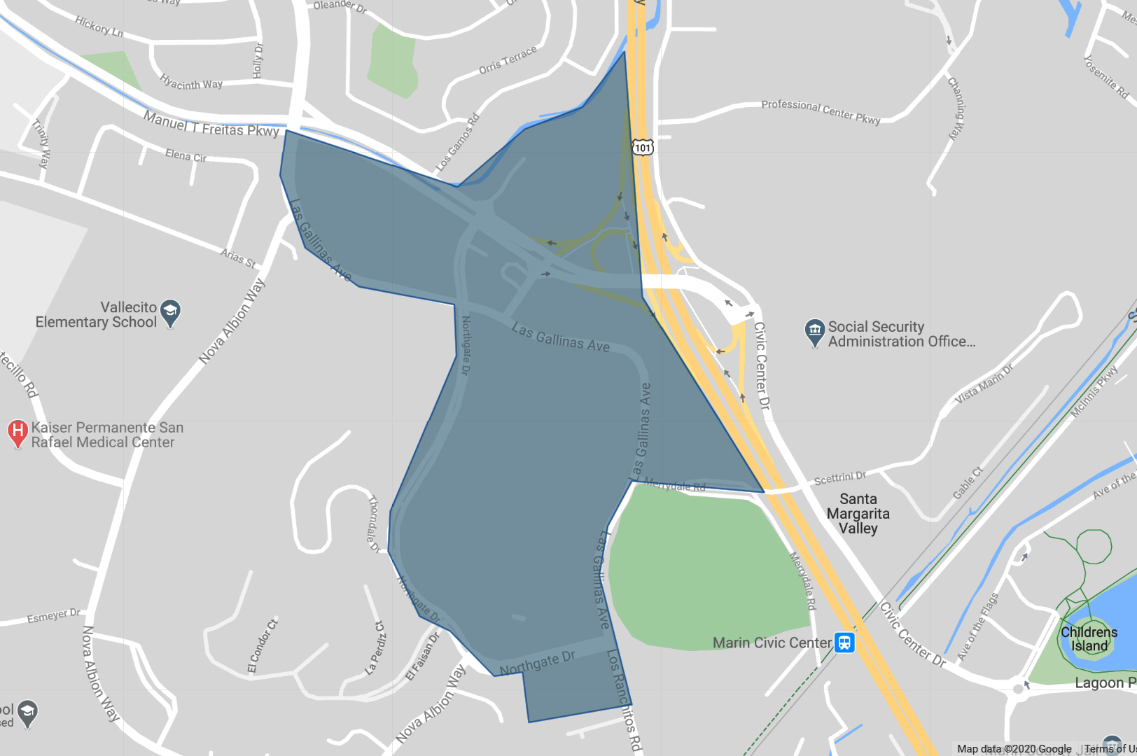
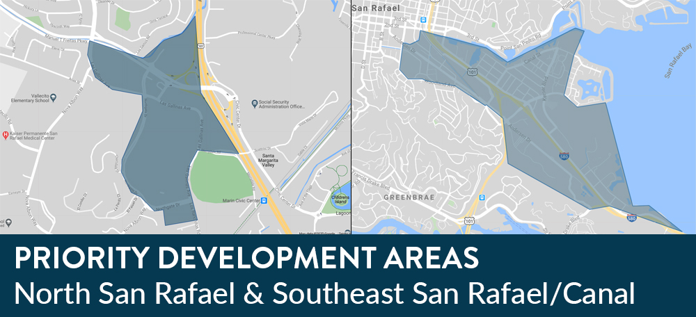
Proposed North San Rafael Priority Development Area  

The Proposed Northgate PDA includes only the PDA-eligible areas surrounding Northgate Mall, Northgate III, and the Four Points by Sheraton, and extending to the intersection of Las Gallinas Avenue and Manuel T. Freitas Parkway. 

Priority Development Area - Southeast San Rafael

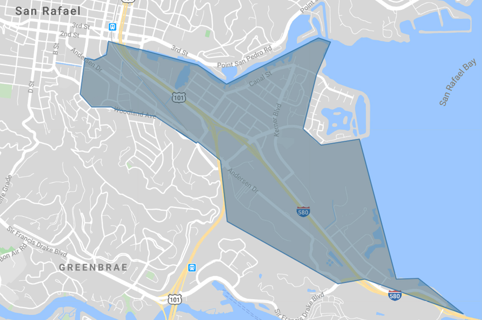
Proposed Southeast San Rafael / Canal Priority Development Area

The Proposed Southeast San Rafael/Canal Priority Development Area (PDA) includes most of Southeast San Rafael/Canal including much of the area east of Hwy 101 and Hwy 580, and the areas along Andersen Dr. and Woodland Ave.


Next Steps 

Over the next three weeks we will seek feedback from the community though this website and virtual community meetings. On June 15, the City Council will consider the community feedback and a resolution finalizing PDA-nominations for San Rafael. 


Acronyms, Terms, & Definitions 

MTC/ABAG: MTC/ABAG is the combination of two organizations. MTC stands for Metropolitan Transportation Commission and ABAG stands for the Association of Bay Area Governments. MTC/ABAG is part regional planning agency and part local government service provider. Learn more 

General Plan: State law requires every city and county in California to prepare a “General Plan” for its future growth and development.  A General Plan covers topics such as land use, transportation, housing, open space, natural resources, and public services. Learn more 

Priority Development AreaA Priority Development Area or “PDA” is a place that has convenient public transit service that is prioritized by local governments (cities/counties) for housing, jobs and services. PDAs range from Downtowns to Main Streets to aging shopping malls. 


More Resources 


Project Contact

Ethan Guy
Principal Analyst – Community Development
ethan.guy@cityofsanrafael.org

Submit questions about the project online


Related Articles

No events could be found.

Close window